

The "Air Alert" app has introduced a map of drone and missile movements: what it shows and what it won't
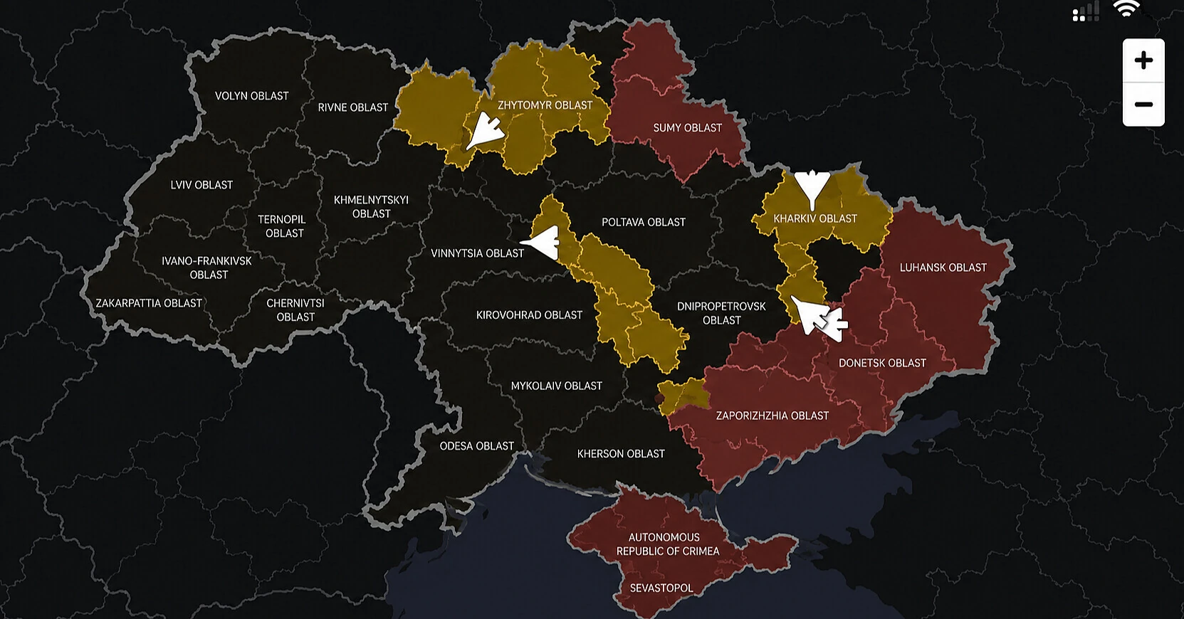
A new map has appeared in the "Air Alert" application, showing the approximate directions of movement of Russian drones and missiles over Ukraine. The feature was officially presented on October 17: the information is verified by the military. However, you will not be able to see the exact location of air targets or track each drone in real time. Let's figure out what the map shows, how it differs from regular notifications, and why it cannot be used instead of an air raid siren.
The launch was announced by Prime Minister of Ukraine Serhiy Koretsky. According to him, the new feature should help people get verified information faster during Russian air attacks, without wasting time searching for messages in social networks and other unofficial sources.
The new map is a joint project of the Ministry of Digital Transformation, the Ministry of Defense, the Air Force of the Armed Forces of Ukraine and Ukrainian IT companies.
What's new in the "Air Alert" app
Previously, the app allowed receiving official air raid alerts and seeing in which regions of Ukraine danger was declared.
Now users have access to additional information — approximate directions of movement of Russian drones and missiles.
On user-posted images of the new map, color-coded areas of Ukraine and arrows indicating the directions of air threats are visible.
The main difference from the usual alert map is that a person receives not only a message about danger in a specific region, but also a general idea of the direction of movement of air targets.
The information used to display threats is verified by the Ukrainian military.
As the Prime Minister emphasized, during air attacks every minute matters for people's safety. Therefore, the authorities are striving to ensure fast access to verified data.
However, the new map is not a full-fledged tracking system for individual drones or missiles.
Why the map doesn't show the exact location of drones
This is the main limitation of the new feature, which was especially emphasized by the Cabinet of Ministers.
The map shows only approximate directions of movement of air targets. The exact coordinates of drones and missiles in real time are not displayed in the app.
Therefore, the arrow on the map should not be taken as the exact route of a specific drone.
The air situation can change quickly. Russian strike drones can change direction, and information about air targets requires verification and updating.
Consequently, even if the map does not show an arrow pointing to a certain locality, it does not mean that danger is absent there.
Similarly, it is impossible to determine from the image how much time is left before a possible approach of an air target.
The official announcement does not specify how often the data is updated and how much time may pass between detection of a threat and its display.
Thus, the map is intended for general information, not for self-prediction of possible strikes.
Where to find the new map and how to get access
The new feature is presented in the "Air Alert" app, which is distributed free of charge for Android and iPhone smartphones.
Those who already use the app should check for updates in Google Play or App Store and see if the new map is available.
At the same time, the official launch announcement does not provide a separate step-by-step instruction for opening the feature. Therefore, the exact location of the map in the interface and the need to install a specific app version are not yet clarified.
If the feature does not appear or the map loads incorrectly, it should not be taken as absence of an air threat.
No officially confirmed technical explanations of possible problems with the new feature have been published at the time of its presentation.
The app itself continues to perform its main task — transmitting air raid alerts.
In it, you can select the region, district or territorial community for which the user wants to receive warnings.
With appropriate settings, the app plays a loud signal even when the smartphone is in silent mode.
Registration is not required to use the service. According to the developer's description, the app also does not need to collect user geolocation data.
Official app pages: Google Play for Android and App Store for iPhone.
Can you rely on the map instead of the air raid siren?
No. The Cabinet of Ministers of Ukraine has separately warned that the new feature does not replace official air raid signals.
If an alert is declared in a locality, you must immediately go to a shelter and stay there until the official all-clear.
Do not delay moving to a safe place trying to determine from the map how close a drone or missile is.
Also, you should not consider the situation safe just because the screen does not show air targets nearby.
The Prime Minister emphasized that the task of the new map is to provide people with quick access to verified information. However, safety decisions must be made based on official warnings, not presumed air target routes.
Who created the app and how many people use it
The "Air Alert" app appeared in March 2022, soon after the start of the full-scale Russian invasion.
It was developed by Ukrainian technology companies Stfalcon and Ajax Systems with support from the Ministry of Digital Transformation.
The service is designed for rapid transmission of official air danger warnings and other threats to the population of Ukraine.
According to Google Play, the number of downloads of the Android app exceeds 10 million. The app is also available to Apple device users.
Over its operation, the service has gained new features. In particular, the developers added additional danger levels for air alerts and updated their visual display.
The map of approximate drone and missile movements became another expansion of the public alert system.
Why the new map can be useful during massive attacks
During large-scale Russian strikes, threat alerts can come from several regions of Ukraine at once.
Official Air Force channels, local administrations and alert apps inform citizens about air danger. Additional messages are spread through social networks and monitoring channels.
In such a situation, it can be difficult for a person to form an overall picture of events, especially if air targets repeatedly change direction.
The new map is designed to make information more visual: instead of having to independently compare messages from different sources, the user will be able to see approximate threat directions in one app.
However, its appearance does not change the basic safety rule.
The map helps to better understand the overall air situation, but cannot guarantee the accuracy of the location of each target or predict the strike location.
Therefore, the main guide for residents of Ukraine remains official air raid and all-clear signals. The new feature should complement this warning system, not replace it.
Based on materials from: Cabinet of Ministers of Ukraine — official announcement of October 17, 2026, Google Play — "Air Alert", App Store — "Air Alert".